Another winter storm is brewing: Warnings issued as another blast of snow expected
Another major winter storm is expected to slam portions of the central and eastern U.S. this week, with heavy snow and strong winds threatening to induce dangerous travel conditions, knock out power and ground flights, forecasters warned.
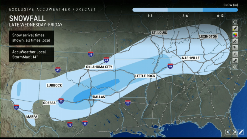
Unlike the deadly storm that barreled over the Midwest and Mid-Atlantic regions days ago, the incoming system will first bring snow to the South before swinging toward the Northeast, where it could bring flurries to Washington, D.C., and other major cities.
Beginning Wednesday night, the storm system will move over Texas, Arkansas and the Tennessee Valley, bringing 4 to 8 inches of snow to a portion of the south-central and southeastern U.S. that has experienced bitterly cold temperatures from a blast of Arctic air.
"In places that don't get snow or ice very often, such as Austin, Dallas, Little Rock, and Nashville, it will be a big deal," AccuWeather meteorologist Tom Kines told Paste BN earlier this week, noting that cities like Dallas could see their most significant snowfalls in several years.
As the storm pushes east, forecasters expect it will bring snow to Nashville, Atlanta and Charlotte, North Carolina, as it begins passing over the Appalachians early this weekend. Major airports throughout the central and eastern U.S. could see delays and cancellations.
Winter storm warnings issued across south-central US ahead of snow
Winter storm warnings in northeastern Texas, southeastern Oklahoma, southern Arkansas and northern Louisiana are set to take effect early Thursday morning and expire Friday afternoon.
The National Weather Service office in Dallas – where the yearly historical snowfall average is 1.6 inches – said the storm could dump 2 to 4 inches of snow in the city and the surrounding area, with some isolated snowfall amounts reaching 8 inches.
If Dallas gets half a foot of snow, it would be among the "top-five snowfalls on record," according to AccuWeather.
"Roads, and especially bridges and overpasses, will likely become slick and hazardous," warned the weather service office in Shreveport, Louisiana. "The strong winds and weight of snow on tree limbs may down power lines and could cause sporadic power outages. Plan on slippery road conditions. The hazardous conditions could impact the Thursday morning and evening commutes."
Dallas may get a year's worth of snow ahead of major football game
The worst of the snow is expected just before football fans flock to Dallas' Cotton Bowl for the national college football semifinal featuring Ohio State vs. Texas.
AT&T Stadium is equipped with a retractable roof, so the game won't be directly impacted by the frosty weather. Traveling to the game will be the issue as drivers will likely face icy and snow-covered roads.
Snow again in the northeast? It's unclear how much the region will get
It's uncertain how much snow, if any, the storm will bring to the Mid-Atlantic and New England. Scenarios vary widely depending on how much momentum the storm keeps up as it barrels over the Appalachians.
"These scenarios range from the storm continuing on nearly straight to the east with little (or no) snow reaching the central Appalachians and upper mid-Atlantic to a storm strengthening and turning northward with an extensive zone of major snow and ice reaching through the mid-Atlantic and into southeastern New England from Saturday to early Sunday," said AccuWeather meteorologist Paul Pastelok in an online forecast.
(This story has been updated to add additional information.)
Contributing: Doyle Rice, Paste BN