California on 'high alert' as looming storm threatens flooding, mudslides, heavy snow
Editor's note: This page reflects news from Wednesday, Feb. 12. For the latest updates on the atmospheric river in California, read Paste BN's coverage for Thursday, Feb. 13.
SAN DIEGO — California officials braced Wednesday for what could be the biggest rain storm of the winter season, prepositioning emergency personnel as they warn residents to avoid traveling during the expected downpours and prepare for possible evacuations.
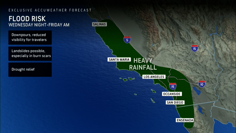
An atmospheric river — the second to wallop the state in recent weeks — will bring 2 to 4 inches of rain to much of the California coast, with over 8 inches possible in some isolated areas, according to AccuWeather. Light rain began falling in parts of the state on Wednesday but the heaviest downpours are expected on Thursday as the storm moves into Southern California.
"This event could bring an increased risk of power outages, flooding in small streams and low-lying areas, and debris, rock and mudslides on roadways," the California Governor's Office of Emergency Services said in a statement. The agency deployed dozens of fire engines, rescue crews and helicopters to respond to potential emergencies in fire-ravaged areas.
The weather service office in Los Angeles said heavy rain over charred land "could trigger life-threatening and damaging flooding and debris flows." Flood watches for portions of Northern California were set to take effect starting Wednesday evening while flood watches in Southern California will be in effect starting early Thursday.
The latest atmospheric river comes after a series of storms brought record daily rainfall to Northern California last week, triggering major floods that damaged houses and forced evacuations and water rescues. Officials said there were at least two storm-related deaths.
In addition to the rain, the incoming storm was set to blanket the Sierra Nevada mountains in multiple feet of snow this week, prompting officials to warn residents to avoid driving on mountain roads.
Officials prepare vulnerable, scorched areas for heavy rain
Ahead of the rain, state and local officials announced several measures to mitigate the potential for flooding and mudslides in areas impacted by the Palisades and Eaton fires that swallowed entire neighborhoods in the Los Angeles area last month.
The California Governor's Office of Emergency Services said it prepositioned over 400 personnel in eight counties to fight floods and debris flows. At burn sites, thousands of miles of concrete barriers have been installed to prevent landslides, while over 300,000 sandbags have been given out to residents and business owners.
Dozens of soldiers with the California National Guard were also deployed to hasten the ongoing debris removal efforts. Officials warned people in areas impacted by the fires to prepare for mudslides by having a "go-bag packed and knowing evacuation routes."
"We have city departments on high alert right now as rain makes its way across LA," Los Angeles Mayor Karen Bass said in a post on X.
The National Weather Service issued a flash flood watch for burn areas in Santa Barbara, Los Angeles, and Ventura counties. Local authorities have urged residents to stay alert for changing conditions, noting that heavier downpours could cause localized flooding or flows in the region.
The Los Angeles Fire Department announced evacuation warnings in areas recently burned by the wildfires due to "possible debris flows." Evacuation orders were also issued for specific addresses where mudslides are a "high risk." The orders will be in effect from 7 a.m. local time Thursday until 2 p.m. Friday, according to fire department officials.
In Orange County, southeast of Los Angeles, a voluntary evacuation warning was issued for residents in the Airport Fire burn area — which burned over 23,000 acres last year. The warning is set to go into effect on Thursday morning.
A number of communities along the Line Fire burn scar and in the San Gabriel Mountains were under evacuation warnings, according to the San Bernardino County Sheriff's Department.
Winter storm warning across the Sierra Nevada mountains
The system will bring several feet of snow and high winds to the Sierra Nevada mountains, triggering winter storm warnings describing "difficult to impossible" travel conditions on mountain passes.
The weather service in Sacramento said snowfall rates could top 2 inches per hour in some areas, lowering visibility that could impact Thursday morning commutes. The heaviest snowfall is expected Wednesday night through midday Thursday.
The snowy weather was not only limited to California. Similar winter storm warnings were set to take effect in Oregon, Idaho, Nevada, and Utah as the weather system moves east over the coming days.
In Oregon's Multnomah County, part of the Portland metropolitan area, officials extended a state of emergency through at least Thursday evening. The county opened six emergency shelters on Wednesday night after a total of 356 people came to the open five shelters on Tuesday.
The National Weather Service in Portland warned that freezing rain and snow will impact parts of Oregon and Washington state overnight into Friday. These conditions were also expected to impact major roadways, including Interstate 5, Interstate 205, and Interstate 84, according to the weather service.
What is an atmospheric river?
Often referred to as "rivers in the sky," atmospheric rivers are long, narrow tracts of the Earth’s atmosphere that gather moisture from the tropics near the equator and sweep it toward the poles.
They can vary greatly in size and strength, however, the average atmospheric river carries an amount of water vapor "roughly equivalent to the average flow of water at the mouth of the Mississippi River," according to the National Oceanic and Atmospheric Administration.
Exceptionally strong atmospheric rivers can move up to 15 times that amount, often leading to "extreme rainfall and floods," NOAA said.
Contributing: Dinah Voyles Pulver, Paste BN; Cheri Carlson, Ventura County Star