Winter wallop again: New snow, ice storm smacking Midwest, East; 90M under alerts
Editor's note: This page reflects news from Wednesday, Feb. 12. For the latest updates on the winter storm, read Paste BN's coverage for Thursday, Feb. 13.
WASHINGTON − The nation's capital was digging out Wednesday after a winter storm slammed parts of the region with a foot of snow while a second storm began hitting the Midwest before rolling east.
More than 90 million Americans were under winter weather advisories or warnings Wednesday. Chicago, Detroit and Kansas City, Missouri, were among places likely to take the biggest hit from the second storm, AccuWeather said.
The first storm barely skimmed the Midwest but dumped more than 6 inches of snow at Ronald Reagan Washington National Airport and twice that amount in parts of Virginia and West Virginia. Residents were shoveling porches and sidewalks while many parents escorted kids to neighborhood parks to sled and build snowmen.
Lauren Weiss, 36, brought her 5-year-old son Seth to Kalorama Park in Northwest Washington. He spent a half hour constructing a snowman and dressed it in a gray scarf and a black top hat.
“It’s always super fun when there’s a good amount of snow on the ground,” Weiss said as Seth grabbed the snowman’s carrot nose and took a bite.
The second storm will cause snow to accumulate for almost 2,000 miles from Colorado to Michigan and New England on Wednesday and Thursday, AccuWeather said. Washington faced a wintry mix while several inches of snow were possible in parts of Maine.
"Bursts of heavy snow, accumulating at times to an inch per hour, may lead to hazardous driving conditions and disrupt travel," Weather Prediction Center forecaster Paul Ziegenfelder said in a summary. "Heavier snow rates should develop in time for the evening rush hour in Milwaukee, Chicago, Grand Rapids and Detroit, among other locations."
Developments:
∎ Over 200,000 homes and businesses were without power across the U.S, including 151,000 in Virginia by Wednesday night, according to the Paste BN power outage tracker.
∎ More than 6,700 flights were delayed across the U.S. and 587 others were canceled, according to FlightAware.
∎ The winter storm has also wreaked havoc on the roads with over 1,000 crashes reported across two states. Virginia State Police tracked 849 crashes by Wednesday morning, with 87 reported injuries. In neighboring Maryland, state police said there have been 235 crashes and an additional 185 inoperable or unattended vehicles.
Nation's capital struggles, sleds in the snow
The federal government's Office of Personnel Management posted a statement Wednesday for hundreds of thousands of employees in the region "suggesting 2 hour delayed arrival − with an option for unscheduled leave or unscheduled telework. Given critical work being done across the federal government, please consult with your agency for final guidance."
Many schools and businesses were closed as plows rolled through the region. At Kalorama Park in Northwest Washington, 4-year-old Benjamin Beeny descended a hill in a snow tube. His mother, Clare Beeny, a lifelong Washington resident, said that combined with the snow that fell last month, this has been the snowiest winter she has seen in years.
“It’s been a great time for snow,” said the second-grade teacher, motioning to her son. “He’s certainly loving it.”
Major Midwest cities target of second storm
The National Weather Service forecast called for 3 to 6 inches of snow to fall in the Chicago area through Wednesday night and 5-9 inches in the Milwaukee area. In Detroit, total snow accumulations of 3-5 inches were forecast, and ice accumulations around one-tenth of an inch were likely while "locally higher amounts of snow and ice will be possible."
South of the heavy snow zone, a wintry mix with ice could sweep across Oklahoma all the way to New England, AccuWeather said. Central states that can expect a slippery wintry mix include Oklahoma City, St. Louis, Indianapolis and Cleveland.
"Major travel disruptions will occur as snow falls on some of the busiest roads and airports in the nation," AccuWeather warned.
Schools closed, delayed because of storms
The Washington, D.C., public schools were closed Wednesday. Almost all public school districts in the region shut down, and the wintry mix forecast for later Wednesday put classes in doubt for Thursday.
Milwaukee Public Schools and most suburban school districts also canceled all classes and evening activities on Wednesday, as did the University of Wisconsin-Milwaukee.
Public schools in Chicago, where the storm could be driving 1-2 inches of snow around the evening rush hour Wednesday, schools remained open. Dozens of suburban districts closed for the day, however. Some schools, such as Alan B. Shepard High in Palos Heights, 20 miles south of Chicago, opened on time Wednesday but scheduled an early release.
First major storms for some cities
The storm could be the biggest of the season for several Midwest cities including Detroit and Chicago, AccuWeather said. Chicago's biggest snow this year was 2.2 inches, measured at O'Hare Airport on Jan. 10. Chicago is among North Central states that are lagging well behind the typical seasonal snowfall thus far, registering only 10 inches of snow as of Monday − compared with a historical average of 24.5 inches for this point in the season.
Snowfall in Milwaukee was at 39% of the historical average for the date; 44% for Minneapolis and 56% in Detroit.
South faces threat of tornadoes, hail
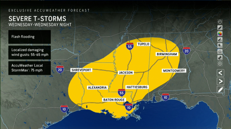
Some southern states were facing the threat of tornadoes as the region faced heavy rainfall and flash flooding.
On Wednesday evening, the weather service confirmed a “large and extremely dangerous tornado” near Coffeeville, Alabama, with potential for hail up to 1.75 inches. Forecasters warned twisters are difficult to spot at night and urged people to take cover immediately.
Just outside Goodwater, Mississippi, a severe thunderstorm capable of producing a tornado was located. The weather service said mobile homes may be destroyed, and damage to trees, roofs, windows and vehicles is likely. Additional parts of Mississippi, Alabama and Louisiana were also under tornado watches.
California braces for mudslides amid atmospheric river
Officials in California are bracing for what could be the biggest rainstorm of the winter season, alerting residents to avoid travel and warning about the potential for flooding and mudslides, especially in fire-ravaged areas. An atmospheric river, the second to wallop the state in recent weeks, will bring 2 to 4 inches of rain to much of the California coast, and over 8 inches is possible in some isolated areas, according to AccuWeather. The rain is expected to begin Wednesday night and move into Southern California on Thursday, when the heaviest downpours are forecast.
"Burn scars (are) the most vulnerable," the National Weather Service said. "The risk of flash flooding will be highest in and near recent burn scar areas in Southern California."
In Santa Barbara County, the sheriff’s office issued evacuation orders and warnings for residents in the Lake Fire burn scar area due to risk of flash flooding, debris flows and landslides. County officials said the rainstorm was expected to continue through Friday and may flood roadways.
The Lake Fire ignited in July and spread 38,600 acres, according to Cal Fire. Read more here.
− Christopher Cann
Why is some snow dry and fluffy and other snow wet and heavy?
Forecasters said the snow that's falling in the Mid-Atlantic is dry and fluffy to the north of Washington, D.C., but heavier and wetter to the south.
Why is this? Air temperature determines the kind of snow that falls – the powder that skiers love or the heavy, wet snow that's hard to shovel.
Wet snow occurs when the air temperature near the surface is above freezing, causing the snowflakes to partially melt before reaching the surface, CompuWeather said in an online report. "This causes the snowflakes to become sticky and easily adhere to and accumulate on nearly all outdoor surfaces," CompuWeather meteorologist Eric DeRoche said.
Dry snow is more common as it occurs when the surface air temperature is below freezing. "Unlike wet snow, dry snow is powdery and cannot easily be formed into snowballs or snowmen," DeRoche said. "In addition, colder air temperatures correlate to lighter and fluffier snow that contains less water per inch."
The weight of snow can vary dramatically: A cubic foot of dry, powdery snow might weigh 3 pounds, while a cubic foot of heavy, wet snow can weigh as much as 10 pounds. Read more here.
Contributing: Doyle Rice, Paste BN; Drake Bentley and Alec Johnson, Milwaukee Journal Sentinel