New winter storm rolling toward East. Will it be a hit or miss for major cities?
The latest in a chain of closely packed winter storms was taking aim at the Midwest on Monday before rolling toward the East for what could be the biggest snow yet to hit the region − or nothing at all, forecasters said.
The good news is the unrelenting string of wintry punches should come to an end this week, AccuWeather meteorologists say.
AccuWeather Senior Meteorologist Tom Kines said the storm was taking shape Monday and taking aim at parts of Nebraska, Kansas, Oklahoma and Missouri. St. Louis was on the northern edge and might get nothing or a few inches, while Missouri cities such as Kansas City and Springfield could get 6 inches or more, Kines said.
"They are going to be shoveling snow, we just don't know how much," Kines told Paste BN.
Developments:
◾ Over a hundred daily record lows could be set through the Midwest on Tuesday through Friday. Subzero lows may spread as far south as Oklahoma, The Weather Channel said.
◾ Wind chills could reach up to 60 degrees below zero for portions of the Northern Plains through midweek. A few readings in the 40s below zero are expected in the coldest spots of Montana and North Dakota through midweek.
DC on the edge of the storm
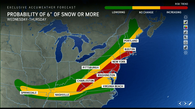
A major question is whether Washington, D.C., will be hit with a third major storm of the season this week. The two previous storms each dumped more than 6 inches of snow on the nation's capital.
Earlier forecasts for the latest storm had the nation's capital facing up to another foot of snow. The National Weather Service said Monday that there was an "enhanced" winter storm threat Wednesday night through Thursday night, and there is an "increased potential for significant travel impacts and closures, if this threat materializes."
Kines said the storm will roll straight across the country to North Carolina, where it will turn north. How sharp that turn becomes is crucial. Eastern cities such as Boston, New York and Philadelphia are likely to be spared, he said. Right now Washington is on the edge, possibly getting no snow or possibly seeing as much as 6 inches.
"We'll know more on Tuesday, but if I were betting I would not bet on a lot of snow," Kines said.
Parts of Southeast could see wintry mix
The weather service warned that the storm could impact parts of North Carolina, South Carolina and Georgia, bringing a possible wintry mix Wednesday and Thursday.
"Confidence is slowly increasing as to the timing of the precipitation across the area, but confidence remains low as to the precipitation type and amount," the weather service said in its Hazardous Weather Outlook.
Kines said parts of Mississippi, Alabama, Kentucky and Tennessee could see ice. Fortunately, it should not last long thanks to days that are creeping longer, providing more sun, he said.
"The sun angle does its work this time of year," he said.