Deadly winter storm brings downpours, fierce winds to the East Coast: Updates
A colossal winter storm slammed the East Coast on Wednesday after tearing across the central U.S., unleashing a barrage of dangerous weather disruptions from hurricane-force winds to blizzard conditions and leaving at least five people dead in two states.
The storm impacts have been felt from the Gulf Coast to the Great Lakes and Atlantic Coast as whiteout conditions forced people off the roads in the High Plains and wildfires broke out amid bone-dry conditions in south Texas. At one point over 400,000 homes and businesses across half the country were without power, though that figure had decreased to around 94,000 by late Wednesday.
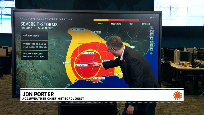
The National Weather Service said preliminary information showed that at least eight tornadoes hit parts of Texas, Oklahoma, and Louisiana on Tuesday.
While many areas will see a respite as the weekend arrives, AccuWeather meteorologists said they are monitoring the potential for multiple rounds of severe weather next week. One possible storm that could develop late next week could spark a "significant outbreak of severe weather" across the central U.S. for several days, AccuWeather said.
On Wednesday, severe weather walloped much of the Eastern Seaboard from the Mid-Atlantic to Jacksonville, Florida. "Damaging winds are the primary threat from these storms, but a few tornadoes can't be ruled out either,'' the National Weather Service said.
The worst conditions are anticipated across southeast Virginia and the eastern Carolinas, where authorities already are dealing with an outbreak of wildfires that began last weekend.
"The rain will be intense enough to knock down or cease the wildfire threat temporarily but will also trigger localized urban flooding of city streets," AccuWeather senior meteorologist Bill Deger said.
The downpours, gusty winds, severe thunderstorms and possible tornadoes hitting the Atlantic Seaboard through Wednesday night will create a risk to lives and property and could trigger power outages and "significant" travel delays, AccuWeather meteorologists warn.
The harsh weather driven by an advancing cold front will span about 100 miles in width but extend more than 1,000 miles from north to south. The heaviest rain and the greatest risk of thunderstorms may only last 6 hours or less, but chaos could be widespread.
Developments:
∎ In Oklahoma, the weather service confirmed five tornadoes were in Okmulgee and McIntosh counties. According to preliminary information, the damage from the tornadoes was consistent with an EF-0 and EF-1.
∎ At least two tornadoes were confirmed in the communities of Darrow and Gramercy, Louisiana, according to the weather service. Damage in Darrow was consistent with an EF-1 and peak winds were estimated at 90 mph while an EF-0 hit Gramercy with winds estimated at 75 mph.
∎ In Texas, a weather service damage survey team confirmed an EF-1 tornado occurred Tuesday in the Fort Worth area. Peak winds were estimated at 110 mph for the tornado, which remained on the ground for about a half mile.
∎ In Florida, Tallahassee schools opened an hour late Wednesday amid concerns tornadoes could develop. The region remained under a wind advisory into Wednesday night; gusts were expected to reach 45 mph.
2 dead in Nebraska amid blizzard conditions
Nebraska state troopers have responded to more than 400 weather-related incidents since Tuesday morning, the agency said Wednesday. The incidents included 31 vehicle crashes and 382 motorist assists.
Earlier Wednesday, the Nebraska State Patrol said severe winter weather in the state contributed to a head-on crash on Tuesday. Two people were killed on Interstate 80 when a vehicle lost control, crossed the median, and struck an eastbound semi-truck, according to the agency.
The agency identified the victims as Emelin Ortega Rodas, 25, of Lexington, and Daniel Ortega Marroquin, 62, of Lexington. The driver of the semi-truck was transported to a hospital with non-life-threatening injuries.
The incident occurred amid blizzard conditions in parts of the state. On Wednesday, the weather service in Hastings and Omaha warned that more snow is expected overnight and into Friday.
"There’s another round of snow coming, with several inches of accumulation expected in northern Nebraska by Friday afternoon. Be safe and stay prepared for winter driving," the Nebraska State Patrol said in a statement.
Tornadoes possible in East
The Weather Channel warned that damaging winds and tornadoes were possible all day Wednesday from Pennsylvania to far northern Florida. Charleston, South Carolina, Raleigh, North Carolina, Richmond, Virginia, and Washington, D.C., are among a slew of cities facing the threat into Wednesday night.
"Large hail and perhaps an isolated tornado could accompany storms that develop in western Pennsylvania, eastern Ohio and northern West Virginia," the Weather Channel said.
Deaths reported in Mississippi
In Mississippi, Gov. Tate Reeves said three people died as high winds swept across the state Tuesday.
"Please pray for their family during this difficult time,'' Reeves said on the X platform, adding that six other people have been reported injured.
WAPT-TV in Jackson reported two of the deaths occurred in Madison County, one when a 71-year-old man came in contact with a downed power line and the other one when a tree fell on a car occupied by a 63-year-old man. The other storm-related fatality took place in Clarke County when a woman was struck by a tree branch that fell in her yard, WLBT-TV in Jackson reported.
The National Weather Service in Mississippi posted a video of the roof ripping off a building at the Clay County Jail. Winds gusting as high as 45 mph on Wednesday could topple large branches and some trees could fall, resulting in more power outages and making travel risky, forecasters said.
Massive disruption of air travel because of storm
Much like Tuesday, when about 350 flights were canceled in Dallas-area airports alone, the rough weather caused major disruptions to air travel Wednesday.
Charlotte Douglas Airport in North Carolina led the way with 176 cancellations and 286 delayed flights through 6:30 p.m. ET, according to the tracking website FlightAware. But the turbulence was widespread, as Washington's National Reagan Airport reported 130 cancellations and 258 delays. Dallas-Fort Worth had 110 cancellations and 327 delays.
Iowa encounters blizzard conditions
In Iowa, crews from the Des Moines Fire Department's Hazardous Materials assisted with clearing an accident scene along Interstate 80 near Wednesday morning. The driver of a semitruck collided with another truck that had previously jackknifed under an overpass, the Des Moines Register reported.
Strong winds were expected throughout the day, leading to blizzard conditions and making winter roads dangerous. A blizzard warning was in effect for much of Iowa. Conditions overnight left roads in western Iowa "nearly impassable" and visibility Wednesday morning was near zero at times, according to the National Weather Service. Snowfall totals in the north-central part of the state reached 9 inches, the Register said.
The dangerous conditions come as thousands try to descend on Des Moines for the Iowa girls' high school state basketball tournament, a major winter event in the state.
Texas bracing for more fires
South-central Texas was facing "near critical" fire weather conditions Wednesday because of the dry air and wind gusts forecast for the area. A Rangeland Fire Danger warning was in effect as 20-mph wind gusts were likely to combine with a minimum relative humidity of 15% to 25%, the weather service said.
Areas of New Mexico and Texas were temporarily shrouded by a brown mist earlier this week, when dust storms known as haboobs swept across the southern Plains on Monday afternoon. More than a dozen fire reports were received by the National Weather Service office in San Antonio and Austin.
Blizzard conditions expected in Midwest
Blizzard conditions are expected "at times" Wednesday from north of Kansas City, Missouri, to Iowa and Illinois and up to the Upper Peninsula of Michigan, and several inches of snowfall combined with strong winds are likely, the National Weather Service said.
"The main concern today will continue to be the high winds with gusts expected to range between 50-65 mph through this evening," the NWS office in Kansas City said on X. The office in Marquette, Michigan, said strong winds along Lake Superior "will result in blizzard conditions, possible tree damage, and potential for power outages."
Contributing: Kate Kealey, Cooper Worth, and Victoria Reyna-Rodriguez, Des Moines Register