Flooding fears rise as saturated rivers swell; death toll at 19: Updates
LOUISVILLE, Ky. − A deadly storm system that slammed a swath of the nation with tornadoes and days of unrelenting rainfall continued to slide through the Southeast on Monday afternoon and evening.
The threat was not over, as "scattered severe storms are expected this afternoon across parts of northern Florida and southeastern Georgia to the eastern Carolinas," the Storm Prediction Center warned in mid-afternoon update. Cities such as Savannah, Georgia, and Charleston, South Carolina, remained in the line of fire.
Meanwhile, in states slammed by the train of storms over the last few days, such as Kentucky and Tennessee, crews pulled people from floodwaters and ordered evacuations, especially near bulging waterways.
On Monday, the Ohio River in Cincinnati reached its highest level in nearly 30 years. Meanwhile, the Kentucky River near Monterey, about 20 miles from the capital Frankfort, was forecast to crest at 57 feet on Tuesday, well above its 33-foot flood stage.
Flood advisories were in effect from Ohio and Illinois to Louisiana and Alabama. And with hundreds of roads still underwater, schools across the region canceled classes and officials urged residents to remain cautious as flooding persists.
"Remember, this event is not over until the water has receded," Kentucky Gov. Andy Beshear said at a news conference Monday.
Two possible tornadoes reported in northern Florida
A line of storms with a history of spawning tornadoes appears to have spun off two twisters near Tallahassee, Florida, on Monday, as reports of damage rolled in from a nasty bout of severe weather.
One tornado was reported around Bloxham, the other around the Lake Iamonia area, where there were reports of damaged structures and trees down on roadways.
Israel Gonzalez, meteorologist with the National Weather Service in Tallahassee, said both tornadoes had tell-tale tornado debris signatures.
“We’re looking at two tornadoes, one in southwest Leon and one in northern Leon County, and that’s about all we can say at this point,” he said. "Nothing (yet) about intensity or how long it lasted."
–William L. Hatfield and Jeff Burlew, Tallahassee Democrat
When will the water recede?
Floods on secondary rivers will be followed by major downstream flooding along the largest rivers in the central U.S. – the massive Ohio and lower Mississippi rivers chief among them.
For example, the Ohio River at Cincinnati remains under a flood warning and is expected to crest at more than 60 feet on Monday before falling below flood stage sometime Friday morning, according to the weather service.
Because water takes many days and weeks to reach a crest then drop below flood stage, some areas along the Ohio and Mississippi Rivers could be underwater for a long period of time. In fact, it may take as much as two to three weeks for the water surge to cycle to the Mississippi Delta region, which eventually would include the New Orleans area.
"The high and fast-moving water will negatively affect tug and barge operations on the Ohio and lower Mississippi rivers," Sosnowski predicted.
– Doyle Rice
High wind gusts, damage reported in northern Florida
Crews in Leon County, Florida, which includes the city of Tallahassee, responded to several reports of storm damage as severe weather ramped up Monday afternoon.
Matt Cavell, a county spokesman, told the Tallahassee Democrat, part of the Paste BN Network, that trees were overturned on roadways, leading to closures, and several structures were damaged. No injuries were reported, he added.
According to the National Weather Service office in Tallahassee, a 64 mph wind gust was recorded in Leon County.
– Tallahassee Democrat
Power outages climb in Georgia
As storms barreled into the Southeast on Monday, power outages began piling up in the region as central U.S. states were still working to restore service to some areas.
More than 10,460 homes and businesses were without power in Georgia as of 12 p.m., according to PowerOutage.us.
Elsewhere, outages impacted tens of thousands of people across multiple states, including Michigan with 44,280 outages; Arkansas, 24,510; Texas, 4,927; and Tennessee, 4,589.
Tornado watches issued across Southeast
The National Weather Service issued tornado watches for a swath of the southeastern U.S. on Monday as a major storm system enters the region, bringing heavy rain and high winds.
The tornado advisories encompassed a wide swath of northern Florida, including the state capital, Tallahassee. To the north, watches were in effect across eastern Georgia and portions of southern South Carolina.
A tornado watch from the National Weather Service indicates that tornadoes "are possible" in and near a certain area. For those under such alerts, the weather service says to prepare emergency plans, gather needed medical supplies and prescriptions, and locate a safe place to shelter in case a tornado does form.
"Be ready to act quickly if a warning is issued or you suspect a tornado is approaching. Acting early helps to save lives!" the weather service says.
School closures abound
As severe weather persisted, school districts in multiple states opted to cancel classes for the day.
Dozens of school districts announced changes to class schedules on Monday, including in Arkansas, Kentucky, Tennessee and Ohio.
While some districts only delayed the start of class, others temporarily moved instruction online and shuttered completely.
It will be days until water recedes, Kentucky governor says
Kentucky Gov. Andy Beshear said at a news conference that hazards remain across the state as areas are still inundated with floodwaters and a strong cold front threatens to plummet temperatures below freezing starting Monday night.
“If you’re trying to ride this out in a home that still has water, tonight could raise concerns of hypothermia,” he said, urging people to find a “safe place to go,” whether a relative's house or an open shelter.
Beshear said two Kentuckians died as a result of the storm, including a woman in Nelson County on Saturday and a 9-year-old boy who was swept away in floodwaters Friday. He added there is an ongoing search for a missing person in McCracken County.
Danger from floodwaters and potential mudslides will remain for “days” and potentially through the end of the week, Beshear said. He stressed the importance of avoiding flooded roadways, noting more than 500 state roads are closed in Kentucky.
How much rain has fallen?
Below are the highest preliminary rainfall totals recorded from Wednesday to Sunday, according to the Weather Prediction Center.
- Benton, Kentucky – 15.59 inches
- Hot Spring Village, Arkansas – 14.14 inches
- Jackson, Tennessee – 12.44 inches
- Ullin, Illinois – 10.98 inches
- Scott City, Missouri – 10.70 inches
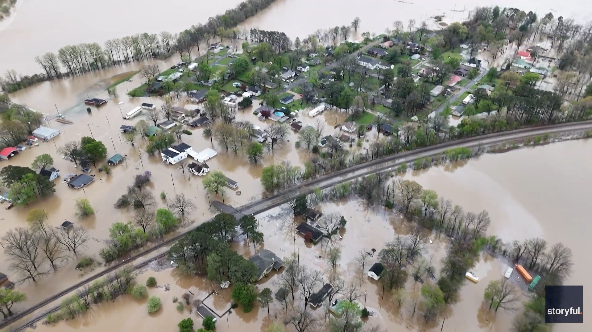
Flooding threat stretches across Kentucky
In east Kentucky, the Red River covered roads and flooded basements and backyards, leaving many residents unable to leave areas of Powell County because of blocked thoroughfares in and out of the area.
In the far west Kentucky city of Benton, the Clarks River inundated roads and turned what would normally be empty fields into lakes, forcing residents to haul sandbags to businesses and homes with hopes of minimizing damage. Benton native Chris Freeland said floodwaters have "never in my life" reached the levels he saw on Saturday.
"All these 100-year storms and 100-year events seem to be happening in the last two years," he said.
For Louisville and communities in Southern Indiana just across the Ohio River, the storm system will rival the February 2018 flooding, one of the worst in recent history. The river is expected to crest at 35.6 feet at Falls of the Ohio by Wednesday, according to data collected by the National Weather Service. Anxious city officials believe it could potentially surpass 36 feet, the crest recorded set in 2018.
Flooding to remain a problem through midweek
The Tennessee Department of Health has confirmed 10 weather-related deaths in the state amid days of severe weather, including tornadoes and flooding. The severe weather was diminishing in some areas, but not the dangers.
"River flooding will be a concern across middle Tennessee through mid-week as well, so remember, Turn Around Don't Drown!" the National Weather Service in Nashville warned Monday on social media.
The weather service said scattered thunderstorms, some with heavy rainfall, severe winds, and tornadoes were possible Monday afternoon across parts of northern Florida and the southern Atlantic Coast.
"Moisture, instability and wind shear will come together to promote the development of thunderstorms that are capable of producing damaging winds and perhaps a tornado or two," the weather service said.
Weather shuts gates at Masters
Monday's forecast for the Masters golf tournament practice round in Augusta, Georgia, called for "periods of heavy rain and a thunderstorm," according to AccuWeather.
The weather forced officials on Sunday to to close the gates for the time being, although they could reopen later Monday if the storms move on.
"All patron parking lots will remain closed until further notice," the Masters said Sunday evening. "No patrons should approach Augusta National Golf Club until more details are released."
The first round of the tournament begins Thursday, which has slim rain chances.
− Jon Hoefling