Flash flood warning issued in Texas as central U.S. braces for rounds of storms
Meteorologists issued flash flood warnings across north-central Texas as much of the central U.S. braces for a series of thunderstorms that threaten to spin up tornadoes, trigger flash flooding, and drop damaging, baseball-sized hail.
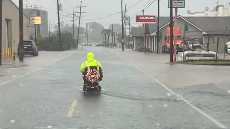
A flash flood warning was issued for Dallas County and surrounding areas, with forecasters expecting rain to fall at a rate of 2 inches per hour. An estimated 2 inches had already inundated the metropolitan area as of early April 23, according to the National Weather Service.
"Flash flooding is ongoing or expected to begin shortly," the weather service said in an advisory.
Through the rest of the week, rounds of shows and thunderstorms are expected to drench much of the Plains region from northern Texas and Oklahoma to Nebraska, Iowa and Illinois, according to the Weather Prediction Center.
"The hazards associated with these thunderstorms are frequent lightning, severe thunderstorm wind gusts, hail, and a few tornadoes," the weather service said. "Moreover, severe thunderstorm wind gusts and hail will be the primary threat over parts of the Central Plains, Middle Mississippi Valley, into the Great Lakes."
These rounds of storms follow a severe weather outbreak over Easter Weekend that spun up damaging tornadoes, uprooted trees and left at least five people dead in Oklahoma.
Power outages climb amid storm in Texas
More than 10,000 homes and businesses were without power April 23 as storms began to sweep across parts of northern Texas, according to PowerOutage.us.
The majority of the outages were reported in the Dallas-Fort Worth area. Utility provider Oncor, which is the area's main utility provider, reported more than 4,000 outages.
"As storms with lightning & strong winds move through North & Central TX, our teams are active & will respond to outage impacts as soon as it's safe to do so," the utility company said in a statement on X. "We encourage customers to check local conditions before attempting travel & keep on hand the ways to contact Oncor."
Rain could ease drought conditions in some areas
The incoming rain, which could reach up to 6 inches in some parts of the central U.S., will be a relief to some drought-stricken areas where wildfires continue to pose a significant danger.
Much of the Plains region is experiencing moderate to severe drought conditions, with some areas, such as southwestern Texas, suffering "extreme" and "exceptional" drought conditions, according to the U.S. Drought Monitor.
"Total precipitation so far this year has been below the historical average for many locations across the Plains entirely, including Wichita, Kansas, and Rapid City, South Dakota," AccuWeather Meteorologist Haley Taylor said in an online forecast.
This week's rain won't completely alleviate the dry conditions across the rain-starved region, but the rain could ease wildfire conditions on the local level.
Some rivers are still rising from last month's heavy rain
The looming storms are rolling into the central U.S. as the region is still dealing with the historic flooding brought by a monster storm system the first week of April. The earlier storm system dumped up to 16 inches of rain across parts of the Ohio, Tennessee and Mississippi valleys, triggering historic flooding across the central U.S.
While the runoff and significant river flooding has largely abated in Ohio and Kentucky, areas downshore, including Baton Rouge, Louisiana, will see rivers crest near the end of the month.
Dozens of flood warnings and advisories remain active due to the high rivers, including the Mississippi River in Memphis, Tennessee, and the Atchafalaya River in Morgan City, Louisiana.