When will Tropical Storm Erin become a hurricane?

Hurricane forecasters say Tropical Storm Erin is set to strengthen into a hurricane and then a major hurricane within a matter of days.
The storm is spinning out in the Atlantic and forecasts show a track heading toward the United States. But with great uncertainty in the long-term forecast track, it's too early to know what impact, if any, Erin will have.
As of 11 a.m. on Aug. 12, the National Hurricane Center predicts the storm will reach hurricane intensity on Thursday, Aug. 14, and become a major hurricane on Sunday, Aug. 17.
Hurricanes have winds of 74 mph or higher and major hurricanes have winds of 111 mph or higher.
The storm, which formed near the Cabo Verde Islands off the West African Coast, is likely to be the first major Atlantic hurricane of the season, forecasters say.
Warm ocean waters and low wind shear are helping Erin along, according to AccuWeather.com.
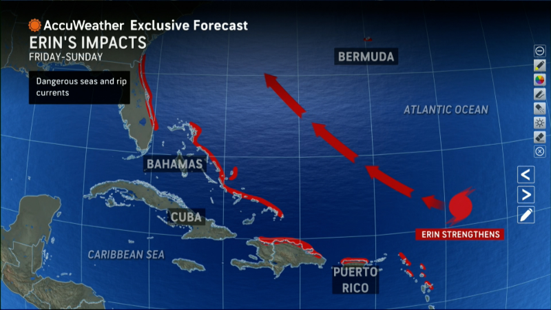
As is often the case with Atlantic hurricanes, Erin's path will be primarily determined by the strength of the Bermuda High, a semi-permanent ridge of high pressure that sits over the Atlantic Ocean in the summer.
The stronger the Bermuda High, the more of a threat Erin is to the United States. A weaker Bermuda High is better news.
"Erin will be guided along by the northeast trade winds initially and then the clockwise circulation around the massive Bermuda High over the central Atlantic," AccuWeather lead hurricane expert Alex DaSilva said.
“Erin will bring gusty wind and heavy rain to northern Puerto Rico as it passes to the north this weekend," DaSilva said in an email. One to 2 inches of rain is expected on the northern side of the island, but there may be pockets that see as much as 7 inches of rain, bringing the risk of flash flooding, DaSilva added. Winds could gust to 80 mph, triggering some power outages as well.
Map shows Erin forecast track
This forecast track shows the most likely path of the center of the storm. It does not illustrate the full width of the storm or its impacts, and the center of the storm is likely to travel outside the cone up to 33% of the time.
Contributing: Chris Cann, Doyle Rice and Joel Shannon