Hurricane Lee tracker: Follow path of 'dangerous' storm as it heads for New England
Hurricane Lee continued to move northwest over the Atlantic Ocean with sustained winds near 105 mph Wednesday evening as it headed toward the coasts of New England and eastern Canada, according to the National Hurricane Center.
Hurricane and tropical storm watches were issued for portions of New England as of Wednesday evening. This means that hurricane or tropical storm conditions are likely in the warned area within the next 48 hours. A storm surge watch was also issued for Cape Cod Bay and Nantucket, Massachusetts.
Lee, now down to a Category 2 hurricane, is "likely to remain a large and dangerous hurricane into the weekend," the hurricane center said. "There is high confidence that Lee will be a large hurricane near the coast of New England Friday night and Saturday."
The storm was about 965 miles south of Nantucket, Massachusetts, as of Wednesday evening. It was moving at 10 mph.
In a Wednesday forecast discussion, the center said "hurricane conditions, heavy rainfall, and coastal flooding are possible in portions of eastern Maine on Saturday. There is the potential for life-threatening storm surge flooding in portions of southeastern Massachusetts, including Cape Cod and Nantucket, late Friday and Saturday."
Meteorologist Ryan Maue, writing on X Wednesday morning, warned that hurricane-force wind gusts could lash the New England coast, including Boston, late Friday or early Saturday.
Lee is a large hurricane
Lee is a large hurricane, as hurricane-force winds extend outward up to 115 miles from the center and tropical-storm-force winds extend outward up to 265 miles.
“Due to Lee’s large size, hazards will extend well away from the center, and there will be little to no significance on exactly where the center reaches the coast,” the center said.
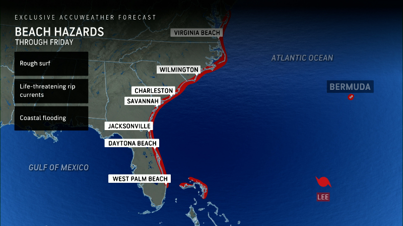
Before it impacts New England, “dangerous surf and life-threatening rip currents” will affect parts of the northern Leeward Islands, Virgin Islands, Puerto Rico, Hispaniola, the Turks and Caicos Islands, Bahamas, Bermuda and most of the U.S. East Coast this week, according to the hurricane center.
Here's a live tracker of Lee's projected path:
Hurricane Lee projected path tracker
This forecast track shows the most likely path of the center of the storm, but does not illustrate the full width of the storm or its impacts. The center of the storm is likely to travel outside the cone up to 33% of the time.
Hurricane Lee spaghetti models
Spaghetti model illustrations include an array of forecast tools and models, and not all are created equal. The hurricane center uses the top four or five highest-performing models to help make its forecasts.