Where will it snow, sleet this week? See states that will be impacted by winter storm
A new winter storm is expected to arrive in the Midwest, Mid-Atlantic and Northeast Wednesday afternoon and last through Thursday, bringing with it locally heavy snow, sleet and freezing rain, according to the National Weather Service.
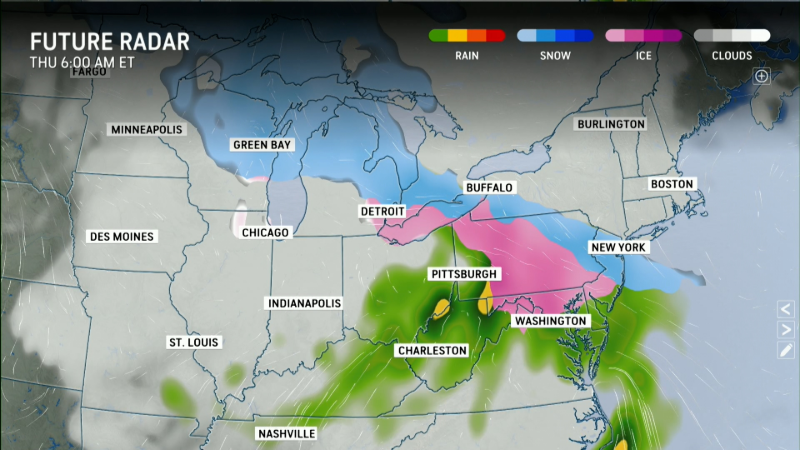
The weather service said Wednesday morning the heaviest snowfall accumulation is expected across the Upper Midwest and the Upper Peninsula of Michigan, along with some interior portions of the Northeast and the central and northern parts of New England.
Just south of that, across the Ohio Valley and the Mid-Atlantic, the NWS said conditions are more conducive for sleet and freezing rain, with locally significant ice accumulations possible. Forecasters are warning that hazardous travel conditions, scattered power outages and tree damage will be possible from the weight of the ice.
"The potential exists for dangerous amounts of ice accretion (build up) into Thursday," said AccuWeather meteorologist Brandon Buckingham. "This poses a risk for tree damage and power outages as the storm moves through."
Where is the ice storm expected?
The storm will start in the Midwest. "Freezing rain and sleet will develop in northern Missouri and Iowa before spreading across the southern Great Lakes later Wednesday and overnight, including Chicago, Cleveland and Detroit," said Weather.com meteorologist Chris Dolce in an online forecast.
"Portions of the mid-Atlantic, including Baltimore, Philadelphia and Washington, D.C., might seeing hazardous travel conditions from freezing rain and sleet Wednesday night into early Thursday morning before transitioning to rain by later Thursday morning," he added.
Areas including Harrisburg, Scranton, State College and Williamsport in Pennsylvania, Binghamton in New York and Cumberland in Maryland face the greatest risk of dangerous ice accumulation, AccuWeather said.
The highest ice storm potential (with 1/4 inch or more of ice buildup) "is expected from western Maryland northward into the Laurel Highlands of Pennsylvania, where scattered power outages and tree damage is most likely," the weather service said.
The NWS' Weather Prediction Center said Wednesday the heaviest icing is likely in western Maryland, the West Virginia panhandle, and central and southern Pennsylvania. Lighter, but still hazardous, freezing rain accumulations are expected elsewhere across the Midwest, Great Lakes, and northern Mid-Atlantic.
"Ice impacts will affect many major thoroughfares including Interstates 81, 80, 76, 70, 99 and 68," the WPC said Wednesday.
Gabe Hauari is a national trending news reporter at Paste BN. You can follow him on X @GabeHauari or email him at Gdhauari@gannett.com.