Heavy rain brings flash flood risk to Gulf Coast as storms target Texas again
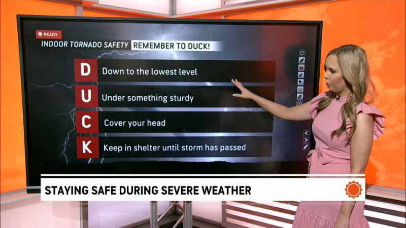
As the threat of severe thunderstorms and potential tornadoes lingers over parts of the Great Plains and Louisiana on May 7, forecasters warned that excessive rainfall could lead to additional flash flooding that has already turned deadly in Texas.
More than 8 million people were under flood watches issued by the National Weather Service across much of Louisiana and parts of Texas, Arkansas and Mississippi. Another pocket of flood watches covered parts of New York state, where rain on already saturated areas could lead to flooding from runoff and full rivers and streams.
On May 6, a 10-year-old girl in Texas was found dead after having been swept away in "rapidly rising flood waters" two days earlier in Brenham, the fire department said. Brenham is located about 90 miles east of Austin.
Meanwhile, another round of strong to severe thunderstorms was a risk in south Texas, with the main threat coming from large hail. More storms are expected across the Tennessee and mid-Mississippi valleys and Central Plains regions.
Houston weather forecast; storms to expand south
Strong to severe storms are expected in the Houston and Galveston area of Texas on May 7, forecasters there said. Widespread showers and thunderstorms will last through early afternoon, with the greatest risk of severe weather south of Interstate 10. Large hail, strong wind and localized minor flooding are all risks.
More rounds of storms are expected on May 8 from western and southern Texas along the Gulf Coast, bringing heavy rainfall and some flash flooding. Louisiana is especially at risk for additional flash flooding and excessive rain.
The rainfall is also set to expand into the Southeast, with 4 to 8 inches across northern Florida, Alabama, Georgia and the Carolinas over the next several days.
"Weeks' worth of rain will fall in a matter of days across parts of the South over the next few days as a storm crawls east," AccuWeather said in an advisory.
Meanwhile, more storms are headed to the Northeast and Mid-Atlantic on May 8, the weather service said. The region was hit by back-to-back thunderstorms in recent days and has more heavy rainfall to look forward to. The rain will be particularly focused on higher elevations of northeastern Pennsylvania, northwestern New Jersey and southern New York, the weather service said.
Flooding turns deadly in Texas
Brenham, Texas, in the east-central part of the state, was inundated by floodwaters amid heavy rainfall on already soaked ground earlier in the week of May 4. The Brenham Fire Department said 10-year-old Devah Woods, a third-grader at Brenham Elementary, was swept away at about 4:25 p.m. on May 4.
Bystanders tried to rescue the girl after she was caught in the quickly rising floodwaters. Crews spent two days searching for her amid ongoing severe weather using dogs, drones and thermal imaging technology. She was found dead at about 10 a.m. on May 6.
"This tragedy has deeply affected our community. We ask everyone to continue thinking and praying for Devah’s family during this unimaginable time. In the face of heartache, Brenham has shown what it means to come together – with strength, compassion, and unity," the Brenham Fire Department said.
At the end of April, back-to-back days of severe storms brought tornadoes, damaging winds and flooding rains to a large swath of the country, leaving at least five dead in Oklahoma and Pennsylvania.
Where is this weather coming from?
The National Weather Service said an "omega block" has been dominating the weather patterns in recent days, but will "finally begin to evolve through mid-week." Unsettled weather isn't over with yet, however.
An omega block is so named because of its resemblance to the Greek letter omega (Ω). According to Weather.com meteorologist Jonathan Erdman, "if you trace the path of the jet stream across the U.S. from the West to the East, you will trace out the Greek letter omega."
"This configuration blocks the typical west-to-east flow of the jet stream, much like a large rock in a small stream forces the flow of water around it," he said. "That's why meteorologists call it a blocking pattern."
It's a type of weather pattern typical of April and May, preventing the typical west-to-east movement of most storm systems. The result is the locking in of chilly and unsettled conditions in some parts of the country while milder and dry conditions exist in between. Read more.
Contributing: Doyle Rice, Paste BN