Tropical Storm Dexter strengthens while moving away from East Coast: See tracker
Editor's note: Click here for the latest update on Tropical Storm Dexter for Thursday, Aug. 7.
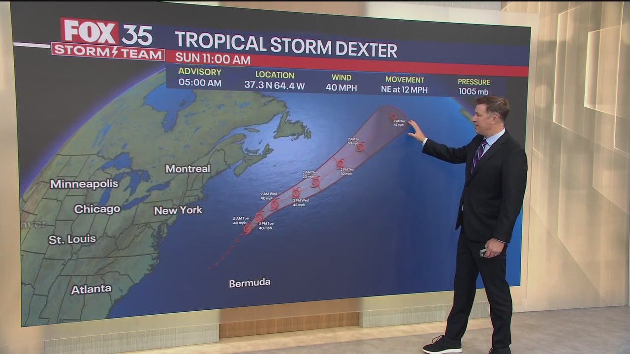
Tropical Storm Dexter has picked up some strength as it continues to drift away from the northeastern U.S. coast, while two other systems continue to brew in the Atlantic Ocean.
The National Hurricane Center said in an advisory on Wednesday morning, Aug. 6, that Dexter is currently located about 405 miles south-southeast of Halifax, Nova Scotia. The storm's maximum sustained winds have increased to about 45 mph with higher gusts.
"Strengthening is forecast during the next 48 hours while the system becomes an extratropical cyclone," hurricane center forecasters said Aug. 6, adding that Dexter is expected to continue moving toward the east-northeast.
Elsewhere in the Atlantic, the NHC said a weak surface trough located several hundred miles off the southeastern U.S. coast is producing scattered showers and thunderstorms. An area of low pressure is expected to develop from this system over the next day or so, and environmental conditions appear favorable for additional development, NHC forecasters said.
A tropical depression could form late this week or this weekend as the system drifts westward before gradually turning northward to northeastward by the weekend. The NHC gives this system a 40% chance of formation through the next seven days.
Lastly, a tropical wave over the eastern tropical Atlantic is currently producing disorganized showers and thunderstorms, with environmental conditions appearing favorable for gradual development over the next few days.
A tropical depression could form late this week or over the weekend as this system moves west-northwestward across the central tropical or subtropical Atlantic, the NHC said, giving the system a 50% chance of formation through the next seven days.
Tropical Storm Dexter path tracker
This forecast track shows the most likely path of the center of the storm. It does not illustrate the full width of the storm or its impacts, and the center of the storm is likely to travel outside the cone up to 33% of the time.
Tropical Storm Dexter spaghetti models
This forecast track shows the most likely path of the center of the storm. It does not illustrate the full width of the storm or its impacts, and the center of the storm is likely to travel outside the cone up to 33% of the time.
NHC also keeping tabs on Tropical Storm Henriette in Pacific Ocean
In the Pacific, the hurricane center said in an Aug. 5 advisory that Tropical Storm Henriette is continuing to move west-northwestward over the central east Pacific, far to the east of Hawaii.
Henriette, located about 1,760 miles east of Hilo, Hawaii, has maximum sustained winds around 50 mph with higher gusts. Some slight weakening is forecast during the next 24 hours, followed by little change in strength during the next couple of days, the NHC said.
There are currently no threats to land from Henriette, the NHC said.
Elsewhere in the Pacific, an area of low pressure currently labeled as EP91 is producing showers and thunderstorms of the Gulf of Tehuantepec and continues to show signs of organization, hurricane center forecasters said.
Environmental conditions are conducive for the development of this system, and a tropical depression is expected to form during the next day or two while the system moves west-northwestward. The NHC gives the system a 90% chance of formation through the next 48 hours.
How do hurricanes form?
Hurricanes are born in the tropics, above warm water. Clusters of thunderstorms can develop over the ocean when water temperatures exceed 80 degrees Fahrenheit. If conditions are right, the clusters swirl into a storm known as a tropical wave or tropical depression.
A tropical depression becomes a named tropical storm once its sustained wind speeds reach 39 miles per hour. When its winds reach 74 mph, the storm officially becomes a hurricane.
Prepare now for hurricanes
Delaying potentially life-saving preparations could mean waiting until it’s too late. "Get your disaster supplies while the shelves are still stocked, and get that insurance checkup early, as flood insurance requires a 30-day waiting period," NOAA recommends.
- Develop an evacuation plan: If you are at risk from hurricanes, you need an evacuation plan. Now is the time to begin planning where you would go and how you would get there.
- Assemble disaster supplies: Whether you’re evacuating or sheltering-in-place, you’re going to need supplies not just to get through the storm but for the potentially lengthy aftermath, NOAA said.
- Get an insurance checkup and document your possessions: Contact your insurance company or agent now and ask for an insurance check-up to make sure you have enough insurance to repair or even replace your home and/or belongings. Remember, home and renters insurance doesn’t cover flooding, so you’ll need a separate policy for it. Flood insurance is available through your company, agent, or the National Flood Insurance Program. Act now, as flood insurance requires a 30-day waiting period.
- Create a family communication plan: NOAA said to take the time now to write down your hurricane plan, and share it with your family. Determine family meeting places, and make sure to include an out-of-town location in case of evacuation.
- Strengthen your home: Now is the time to improve your home’s ability to withstand hurricane impacts. Trim trees; install storm shutters, accordion shutters, and/or impact glass; seal outside wall openings.
Gabe Hauari is a national trending news reporter at Paste BN. You can follow him on X @GabeHauari or email him at Gdhauari@gannett.com.